
The Pannonian Basin is warmer at depth than almost anywhere else in continental Europe. Geothermal gradients here average roughly 45–50 °C per kilometre against a European average closer to 30 °C, and terrestrial heat flow runs at around 90–100 mW/m² [1; 2].
A temperature that takes 3,000 m of drilling in western Europe is often available here 1,000 to 1,500 m shallower. That is a real commercial advantage, because drilling dominates the cost of a geothermal project and cost rises with depth faster than temperature does. It is also the fact most often misread. A high gradient tells you how hot the rock is. It tells you nothing about whether you can get water, or enough water, out of it.
Where the heat comes from
The crust beneath the basin is thin, around 25–30 km, the result of lithospheric extension and thinning during the Early to Middle Miocene (about 20 to 11.5 million years ago) [3]. The mantle heat source sits closer to the surface, and the thick sedimentary fill above it insulates.
The underlying causal relationship can be described in a relatively straightforward way: lithospheric extension thinned the crust and lithosphere, contributing to elevated heat flow and, consequently, a high geothermal gradient. The mechanism itself is not unique. What makes the Pannonian Basin special is the combination and the regional extent of the thermal conditions that result.
The gradient is not a single number for the basin. The profile differs between the young sedimentary basin fill and the varied formations of the basement beneath it, and it varies laterally as well. Basin-wide averages are useful for screening and not much else.
Temperature is not the only target
In a conventional hydrothermal system, heat is brought to the surface by the produced water. A well that finds 130 °C rock and yields no water is a failed well: it is non-productive and it costs almost as much as a successful one. What a project needs is a reservoir: a formation permeable enough to deliver a sustainable flow rate, and, for energy use, somewhere to put the cooled water back.
The Pannonian Basin offers two main targets. The Late Miocene–Pliocene deltaic sandstones of the basin fill are the workhorse: laterally extensive, relatively straightforward to explore, moderate in temperature, with reinjection as the difficult part. The older fractured pre-Tertiary carbonate basement is the alternative: deeper, geologically more complex and with a lower success rate, but capable of much higher yields and temperatures [2].
The distinction dictates how a well is planned. In a basement-hosted system, for example, the productive zone may be the top of the basement or a fault/fracture zone within it. Identifying the location and geometry of these zones is therefore a critical geological targeting task before drilling begins.
What the basin does give you
Shallower wells for the same delivered temperature mean less capital exposed in the exploration well, and the first well carries the largest uncertainty in any geothermal development.
The basin is also unusually well characterized in the subsurface, mainly because of decades of hydrocarbon exploration: temperature logs, formation tops and seismic acquired to find oil and gas are directly usable for geothermal screening.
Hungary in particular has excellent subsurface data coverage and data accessibility. Geological and geophysical datasets are managed by the state-run Geological Survey and a wide range of them is open to the public [5; 6; 7; 8]:
- OGRe, the Geothermal Information Platform
- State Geological, Geophysical and Mining Data Store
- Hydrogeological Data Store
- Geothermal Data Room
- SZTFH map server, with a broad selection of online maps and the national well database
On top of that sits a long history of thermal water utilisation, with hundreds of thermal baths in use across the basin [1; 2]. OGRe, the online database of the Geological Survey, lists 1,825 thermal water wells in Hungary with an outflow temperature above 30 °C. Of these, 1,171 were active in 2026 (Figure 1) [4].
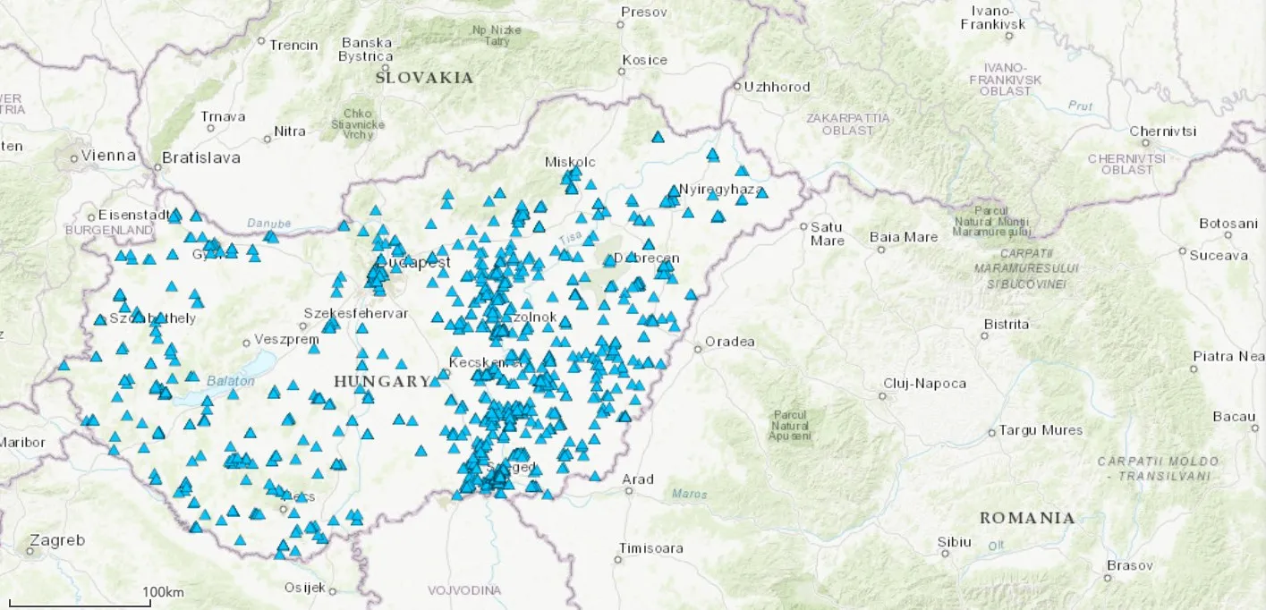
Figure 1: Active thermal water wells in Hungary (blue triangles)
Why the basin is still under-developed
The constraint is rarely the resource. It is usually the heat offtake. A well earns nothing until something is connected to it at a workable price. In Hungary, residential heat prices are regulated and most district heating networks were designed for high supply temperatures, which narrows the range of schemes that work commercially [9].
After that come the cost of capital for a first well, licensing regimes that differ across all nine countries the basin spans, and the shortage of teams able to carry a project from resource assessment through permitting to commissioning without handing it between firms. Every handover loses subsurface understanding, and the subsurface understanding is what the project is built on.
Working with MS Energy Solutions
MS Energy Solutions works in the Pannonian Basin, from Budapest and from a subsidiary in Cluj-Napoca, Romania. Our services cover the full geothermal project lifecycle: resource assessment and exploration, feasibility, design, permitting, implementation and commissioning. Since our establishment in 2007, we have delivered a wide range of geothermal project services, primarily in Hungary, with a number of projects also completed in Romania. Our work has covered both design, permitting and construction of classic geothermal heating infrastructure, including the assessment of geothermal district heating possibilities for municipal partners, and the design, permitting and construction of closed-loop geothermal heating systems with our WeHEAT technology. We also carry out geothermal resource assessments for companies and municipalities.
If you are assessing a site in the region, get in touch or read more about our geothermal project services.
Sources
- Lenkey, L., Dövényi, P., Horváth, F., Cloetingh, S.A.P.L., 2002. Geothermics of the Pannonian basin and its bearing on the neotectonics. EGU Stephan Mueller Special Publications Series 3:1–12.
- Horváth, F., Musitz, B., Balázs, A., Végh, A., Uhrin, A., Nádor, A., Koroknai, B., Pap, N., Tóth, T. & Wórum, G., 2015. Evolution of the Pannonian basin and its geothermal resources. Geothermics 53: 328–352.
- Csontos L., Nagymarosy, A., Horváth, F., Kovác, M., 1992. Cenozoic evolution of the Intra-Carpathian area: a model. Tectonophysics 208, 221–241.
Web sources
- SZTFH. OGRe – Geothermal Information Platform. https://map.hugeo.hu/ogre_en/
- HUGEO. Magyar Állami Földtani, Geofizikai és Bányászati Adattár (State Geological, Geophysical and Mining Data Store). https://hugeo.hu/hu/adatbank/adattar/magyar-allami-foldtani-geofizikai-es-banyaszati-adattar
- SZTFH. Vízföldtani Adattár (Hydrogeological Data Store). https://sztfh.hu/tevekenysegek/foldtani-tevekenyseg/vizfoldtani-adattar/
- HUGEO. Digitális Adatszoba (Digital Data Room). https://hugeo.hu/hu/adatbank/adattar/digitalis-adatszoba/digitalis-adatszoba
- SZTFH. SZTFH térképszerver (SZTFH map server, with the online maps and the national well database). https://map.hugeo.hu/
- Hungarian Energy and Public Utility Regulatory Authority (MEKH). Introduction. https://mekh.hu/introduction